Field Visit 2/12: Mud, Mud, and More Mud
- Will Nuckoles
- Feb 20, 2024
- 5 min read
Desiree and I drove down to Iron Gate dam again on Monday morning. The river below the dam was running thickly and almost black with sediment. We met Juliet Grable, a reporter doing a story on Desiree and Kristine's work, and checked in for the day. The first excitement of the day came on the viewing platform at the construction offices, which are right above Iron Gate Dam. The reservoir was empty! Only a small, shallow pool perhaps 200 meters long remained.
We grabbed photos from the cameras and Desiree kept up the whole day, despite having broken her ankle just the week before. I guess a broken ankle is not a good enough reason to miss the biggest dam removal ever! The river was single-thread with shallow, low-angle banks throughout both reservoir reaches. No knickpoints were present. Meander bends had increased and the river had widened and incised since my last visit. In fact, in much of the upper reaches of the reservoirs, the river had cut into gravel and cobbles suggesting that it may have already returned to its historic bed elevation throughout a substantial portion of the reservoir reaches.
Below are the Timelapse videos of the last two weeks as well as stills from the visit.
Link to a map of the camera placements: https://www.google.com/maps/d/u/0/edit?mid=1rMMqElwDrDyP-kjr4Mj6fzcuVzDrIvw&usp=sharing
IG01:
Reservoir draining at IG01. Note large mudflows throughout the frame on both sides of the river
IG02:
Reservoir draining from IG02. Note again mud flows on both banks, especially associated with the perched tributary on the left of the image. Note also the resumption of river flow towards the end of the video
IG03:
Reservoir draining from IG03, looking upstream at the confluence of Scotch/Camp creeks. Note the large point bar that drains mud flows to the center and just out of frame of the image. Note also the delta formation and channel incision of Scotch Creek.
IG04:
Reservoir draining from IG04 looking upstream at Scotch/camp creek confluence and up into the eastern arm of Iron Gate reservoir. Mudflows are extensive as the reservoir drawdown. Note the formation of a gravel delta/point bar at the mouth of the creek and the composite bank on the far side of the creek indicating it may have incised to its historic bed elevation. Note that the channel is being narrowed by the banks flowing into the channel, but widens and incises simultaneously as the rate of bank failure slows.
IG05:
Reservoir draining from IG05 looking down Scotch creek and across the mainstream Klamath. Large mudflows race down the creek and into the Klamath. The creek incises, widens and develops meanders as soon as mud flows slow. It quickly finds close to its historic channel location and elevation (still flowing through old bridge abutments and presence of gravel/cobble bed). Note development of surface disturbances in the mainstream Klamath indicative of gravel/cobble bedforms and slowing incision rates.
CP01:
Channel is mostly stable with some incision and small mudflows
CP02:
The bend in the center of the image becomes more gradual. Mudflows constrict the channel but as the rate of sediment delivery from the banks slow, the channel incises and widens
CP03:
Meander bend develops, channel widens and incises. Note large circular patterns indicative of retrogressive slumping failures, some of which continue to be active. Note development of point and mid-channel bar and the presence of coarse bed material. A steep, high-angle bank begins to form in the bottom center of frame towards the end of the video as high-velocity flow (from bar constriction) cuts into the draining sediment.
CP04:
Large retrogressive slump failures continue to deliver sediment to the channel. The channel incises, widens and continues to develop the meander bend in the center of the image as well as a gravel point bar in the center of the frame. The meander is continuing to grow via the eddy in the lower left of the image.
Below is a series of stills from the day.

View of Iron Gate reservoir from the construction office viewing platform. Note ponded water

Science safety is serious. Seriously! Adjusting the camera at IG01

View across at tributary visible in IG02 video. The railroad grade has created a hanging valley type feature. Note subsurface flow and deep, steep banks in upper tributary

Desiree downloading photos at IG02. Not pictured is the steep, rocky climb to get here. Do not share with Desiree's orthopedic doctor.

View of the large point in IG03 video. Note outlet in center of frame where mudflow drained off the point

Adjusting the view at IG03. A schematic of the attachment process

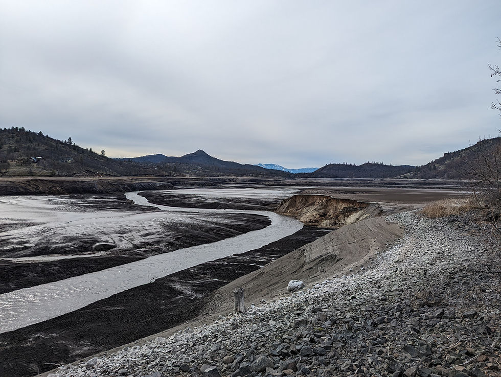
A view at the Scotch creek confluence. Note composite bank and gravel delta. Also note the gravel becoming exposed on the main stem Klamath. This river may already be close to its historic bed elevation in this part of the reservoir!


View of scotch creek near confluence. Note flow through old bridge abutment, composite banks, large meanders and mud flows.

One of only a few large slab failures present on the reservoir rim. Note hillside seeps, which were extensive throughout the reservoir and may be associated with this bank failure. Note too the gravel/cobble banks and large surface disturbances in the main river

Desiree and Juliet for scale at the reservoir rim at Copco Cove, just upstream from Copco dam

Desiree's view from the position pictured above. So much mud!
Large cutbank at CP02 has not experience more failures but the channel has been active as seen in video CP02

A cool feature seen throughout Copco reservoir, pictured here near CP03. The channel has incised and migrated towards the bottom of the frame, leaving behind the smooth sediment. The large retrogressive slumps (with distinctive circular pattern) have then continued to fail and are flowing over the old channel.

Looking downstream from CP03. The channel has widened, incised and migrated left with mud flows following it (not surface cracking and circular patterns)

Mid-channel bar in CP03. Note large grain sizes present on the bar and the increased velocity downstream of it which is contributing to the steep bank on the center right of image

An old tree sees the light of day after 100 years underwater

View from CP04 placement. Note incision in the bottom right of image and gravel point bar in center. Note also the eddy that is continuing to erode the bank on the bottom left of image. There is also a very large retrogressive slump failure present in background of image, among the dead trees

Wide view of the meander bend at CP04

What was that about safety? I seriously need to move this camera

New CP04 placement just downhill from previous and example of standard camera attachment and aiming. Desiree scopes dead deer in the background
What an honor to be studying this place and holy moly has it been exciting so far! I can't wait to go down again.


Comments